



Onboard electronic chart systems rely on Global Navigation Satellite Systems (GNSS) to locate our position, speed and course over the ground
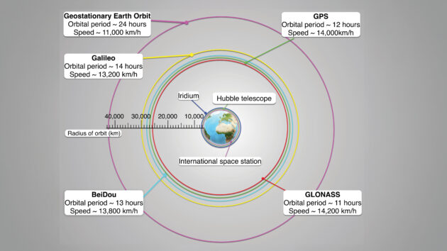
There are nearly 10,000 satellites in space, and this number is changing regularly while new constellations are launched and others reach the end of life.
In the maritime domain, alongside position fixing, satellites are used for long-range communications and safety systems, receiving distress messages from emergency position indicating radio beacons (EPIRBs) and personal locator beacons (PLBs) and long-range internet connections.
The varying constellations are divided into three main categories according to their altitude:
Geostationary earth orbit (GEO)
As the name suggests, GEO satellites in this area are stationary.
Technically, they are orbiting the earth but at a great altitude (around 36,000km) their orbital speed is the same as the earth’s.
This results in them having the same constant footprint on the earth’s surface.
Geostationary satellites cover most of the earth’s surface 24 hours a day, their permanent blind spots being the polar regions.
GEO satellites are useful for applications such as satellite television as it allows the user’s satellite dish to point in one fixed direction.
We also use GEO constellations to receive distress messages sent via EPIRBs and PLBs, and for GNSS satellite-based augmentation systems (SBAS).
Medium earth orbit (MEO)
These constellations are at around 19-23,000km above the earth’s surface and have an orbit time of around 12 hours.
This means the satellites’ speed is around 14,000km/h! It’s at this altitude we find our GNSS satellites.
In recent years the Cospas Sarsat system (the system that receives and delivers distress messages from EPIRBs and PLBs) is also transitioning to utilise more MEO satellites.
Once fully functional it will allow for fully global coverage and near real-time beacon detection.
Low earth orbit (LEO)
The LEO satellites, closest to the earth’s surface with an altitude of 300-500km, are mainly used for communication.
At this altitude we also find the International Space Station.
These constellations have the smallest footprint on the earth’s surface at any one time.
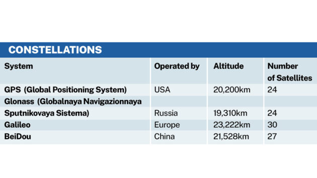
The GNSS network of satellites comprises four main constellations.
GNSS Satellites
The GNSS network of satellites comprises four main constellations.
Historically we needed to purchase a GNSS receiver that was suited to just one of these systems. Meaning that there was limited visibility of satellites.
However, in recent years it has become common to be able to use multiple GNSS constellations to obtain a position.
This increases the likelihood of position accuracy.
Each GNSS system uses its own constellation of satellites to transmit a signal that allows a GNSS receiver to calculate the distance from the satellite.
This gives a large circle of possible locations of where we are. With more satellites we can increase this accuracy.
To explain, try thinking of the satellite transmission as a sound transmission, and imagine the satellite as a lighthouse with a sound signal (other than a lighthouse isn’t moving but the satellites are).
We can calculate a distance from a lighthouse if we know the time it made the sound, and the time we heard the sound.
Working on the assumption that sound travels at around one mile every five seconds (see Figures 1-3).
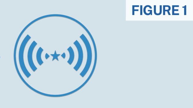
Figure 1. Credit: RYA
Fig. 1 At 1200 a sound is made from the blue lighthouse (the star in the centre of the circle).
We hear the sound 15 seconds later. This means we could be anywhere three miles away from the lighthouse, ie on the blue circle. In the maritime context we’d say the lighthouse has a three-mile range.
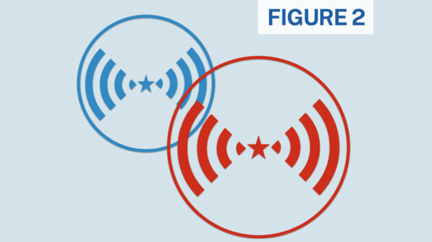
Figure 2. Credit: RYA
Fig. 2 The red lighthouse also makes a sound, which takes 20 seconds to reach us.
This gives us a four mile range from the red lighthouse and is indicated by the red circle.
The two points where the blue and red circles cross are our possible locations.
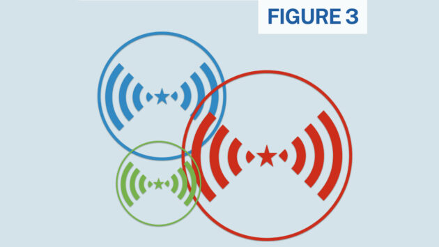
Figure 3. Credit: RYA
Fig. 3 The green lighthouse now makes a sound that takes 10 seconds to arrive, this puts you two miles away from the green lighthouse.
Where all three circles cross is where we are. GNSS systems use this general principal, using transmissions around 1.6GHz in the electromagnetic spectrum, to identify circles of where we could be on the earth’s surface and establishing our position by identifying the location with multiple circle intersections, albeit using much more complicated technology than our simple explanation.
We need at least four ‘in view’ satellites in clear view of your receiver to create a horizontal position, ie latitude and longitude.
The more widely spread these satellites are, the more accurate the position fix will likely be.
A calculated value we can find in most GNSS receivers is horizontal dilution of precision (HDoP), which is an indication of accuracy based on the geometry of the satellites being used.
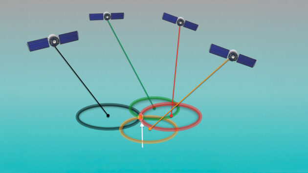
Figure 4: Low Horizontal Dilution of Precision. Credit: RYA
Fig. 4 shows four satellites with good geometry leading to a relatively small area where all four circles intersect.
This would give a low HDoP and therefore higher accuracy that we are where we think we are.
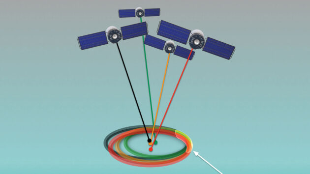
Figure 5: High Horizontal Dilution of Precision. Credit: RYA
Fig.5, meanwhile, shows four satellites that are bunched together leading to a large area where all four circles intersect.
This would give a high HDoP and therefore, a lower level of accuracy.
With a HDoP number around 1, we can expect GNSS positions to be accurate to a few metres, numbers above 2 should increasingly prompt extra caution and increased use of non-GMDSS techniques to verify position.
HDoP is an inbuilt system-monitoring function based on the availability of satellites in clear view and the geometry of those satellites.
A high HDoP value means increased risk of inaccurate positioning but doesn’t automatically mean a low value guarantees good positioning.
As with most systems, there are vulnerabilities external to the system that can affect the accuracy of position or fail the system entirely.
While at sea, the most common interference comes from atmospheric conditions which affect the speed and/or direction of the satellite signals on their way to GNSS receivers, leading to errors in position (see Fig.6).
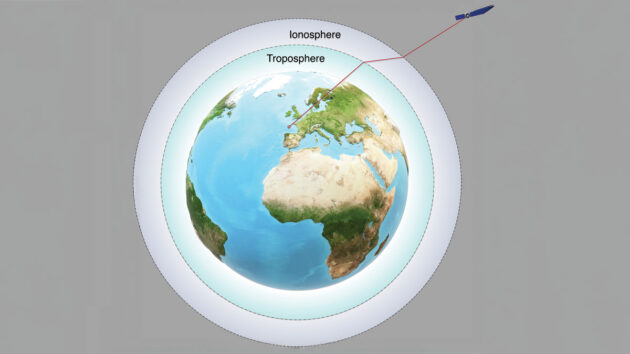
Figure 6: Atmospheric interference can impact GNSS receivers. Credit: RYA
To combat this problem, modern GNSS receivers can enable satellite-based augmentation systems (SBAS).
SBAS systems have dedicated ground stations that compare their GNSS position against their actual position to provide corrections to GNSS signals.
These corrections are distributed via geostationary satellites covering the geographic area of the specific SBAS.
There are four existing SBAS systems as detailed in Fig.7.
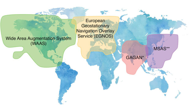
Figure 7: Satellite based augmentation systems (SBAS) areas.
*GPS-Aided GEO Augmented Navigation
**Multi-functional Satellite Augmentation System
Note that while SBAS systems continue to be developed they are a long way from being globally available.
A similar cause of error, but not quite as technical, is multi-path signals, as seen in Fig.8, where a signal reflects off objects on its way to a GNSS receiver’s antenna, leading to the impression that the satellite is further away than it actually is, and therefore an error is introduced.
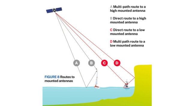
Figure 8: Routes to mounted antennas. Credit: RYA
In the boating world, these errors are likely to be in areas with high cliffs or in high-sided waterways.
Luckily for us, these areas are typically where radar and non-satellite-based navigation is already a priority for the navigator.
The multi-path error is also the reason we should mount our antennae low down, with a clear view of the sky rather than the top of a mast.
An extreme version of the atmospheric interference is the impact of solar flares or storms.
These can change the behaviour of satellite signals such that a receiver will not be able to lock on to a sufficient number of satellites.
In recent years, warnings of interruption have made mainstream news headlines. Unfortunately, SBAS cannot produce corrections for these types of events.
Human interference on GNSS signals
Sadly, there is also deliberate disruption of GNSS signals for malicious purposes. GNSS signals are quite weak and therefore can be disrupted by stronger radio signals.
Jamming and spoofing are two forms of disruption that utilise devices in the proximity of the GNSS receiver.
- Jamming is where deliberate radio interference in a proximity prevents a GNSS receiver from locking on to satellite signals leading to a poor, or no, position being available.
Jamming is relatively easy to do on a small scale but is more difficult to do on a larger scale. - Spoofing is a more sophisticated type of interference that fools the receiver into locking on to a false GNSS signal, meaning the GNSS receiver can present incorrect positions, SOG (Speed over Ground), and COG (Course over Ground).
If the general principals of good navigation are followed, then you will identify when the GNSS position and information isn’t making sense and can continue using the secondary means of positioning you have identified in your passage plan.
A key part of safe navigation is not to rely upon one source of information, such as GNSS. Credit: Damkier Media Group/Alamy
Smart device phenomena
It is estimated that 70% of the world’s population own a smart device.
In the maritime sector, onboard electronic chart systems (ECS) are able to sync to smart devices to share vessel data or act as an independent monitor of the main ECS.
There are also a huge number of navigation apps aimed at the leisure market.
The chip set in smart devices is usually designed to be very power efficient.
Therefore, the system is often referred to as assisted GNSS as the device uses techniques to help find your position such as wifi connections, Bluetooth, near field technology (NFC), phone cell towers and, in some mapping apps, camera augmentation.
Many of these augmentations are not available when at sea, so in many cases the position becomes less accurate, and power usage will increase for the receiver.
Where a smart device can be linked to a power supply and gain inputs from external systems to provide a more robust GNSS receiver and other data, then there is no real reason for it not to be used as part of a navigational approach.
However, if it is entirely dependent on its own battery life, internal GNSS, and cell towers or an internet connection to be fully functional, it risks being a single point of failure.
It is for this reason the RYA does not recommend a smart device used in isolation as a primary part of safe navigation.
The bigger picture
To be able to pinpoint your position on the globe to within 50m with no effort would have been unbelievable for navigators such as Columbus or Magellan.
Today, we have free access to multiple global satellite systems that provide positioning accuracy to within a few metres, requiring no training or understanding of how they work.
However, to ensure safety at sea, it’s crucial to have a better understanding of these systems and how they work to make informed decisions.
While GNSS positions are remarkably good most of the time, there are scenarios that give poor or no position and sufficient independent monitoring is the way that we mitigate for these relatively rare scenarios.
We also need to remember that even if a GNSS position is accurate to within 20cm on their model of the world, it can still show at an incorrect position on your chart display.
Why? Because there are errors that exist within chart surveys due to the age or type of survey used to create the chart.
There are also changes to navigable channels due to erosion, silting or dredging that may not yet be shown on digital or paper charts.
As navigators, we need to understand when an absolute position – such as a latitude and longitude calculated by a GNSS receiver against the World Geodetic System (WGS 84*) – is sufficient with a light touch on monitoring, and when a relative position such as, ‘I am 25m from the isolated rocky outcrop’ becomes much more useful.
The proximity of dangers will inform this and the provision of aids to navigation such as transits, buoyage systems and racons will prompt us to make good use of the aids to relative positioning rather than the position on a mathematical global model.
*WGS 84 is a model of the earth used by the GPS system and most commercial GNSS receivers. Each GNSS uses its own model against which their latitude and longitude positions are calculated.
About the author

Craig Burton is head of training operations at the Royal Yachting Association (RYA)

PBO’s new eNav in a Nutshell series is supported by Navimaps.co.uk – experts in marine cartography – Navionics & Garmin Navionics for chartplotters.
GNSS-enabled electronic devices have ‘cyber-security vulnerability’
Sailors are being warned of the threat of spoofing or jamming of electronic kit, such as Man Overboard (MOB) devices…
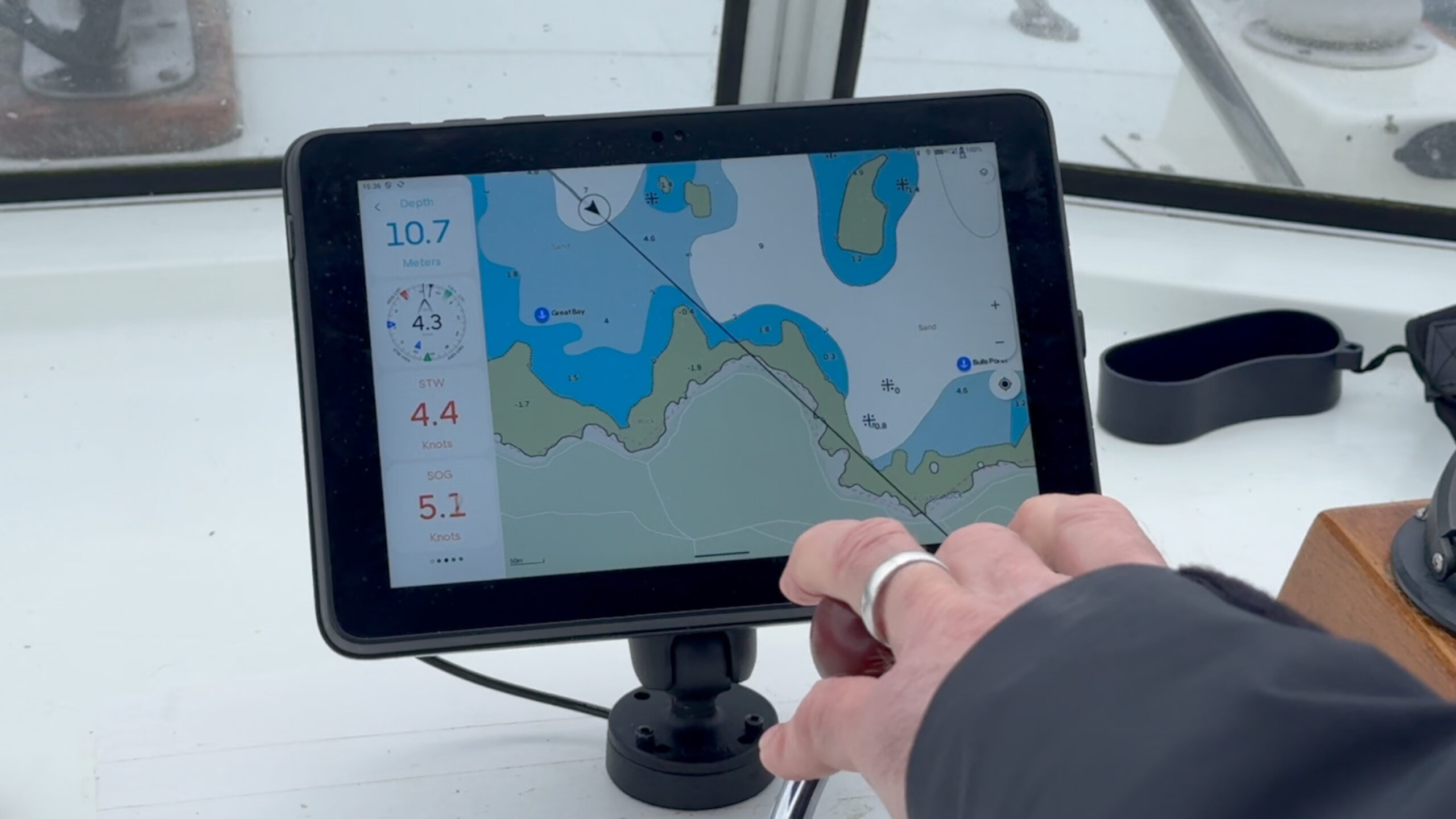
Is the upgraded Orca Navigation System better than a traditional chartplotter? We test it over 450 miles to find out
Justin Morton puts the latest Orca display and software to the test over 450 miles to see if it performs…

New AIS MOB device rule affecting sailors
Big changes to marine radio device rules are planned to be brought into the UK. The only MOB AIS devices…

What to read more features like How does GNSS work?
A subscription to Practical Boat Owner magazine costs around 40% less than the cover price.
Print and digital editions are available through Magazines Direct – where you can also find the latest deals.
PBO is packed with information to help you get the most from boat ownership – whether sail or power.
-
-
-
- Take your DIY skills to the next level with trusted advice on boat maintenance and repairs
- Impartial, in-depth gear reviews
- Practical cruising tips for making the most of your time afloat
-
-
Follow us on Facebook, Instagram, TikTok and X