
Sailors are being warned of the threat of spoofing or jamming of electronic kit, such as Man Overboard (MOB) devices and chartplotters, which have Global Navigation Satellite System (GNSS) functionality.
Safety and communication systems, very high frequency (VHF) radios, emergency positioning indicator radio beacons (EPIRBs) and even oily water separators are among those with GNSS functionality or a Global Positioning System (GPS) chip. GNSS is a system consisting of GPS (USA), Galileo (EU), GLONASS (Russia) and BeiDou (China).
Dr Ramsey Faragher, director and chief executive officer for the Royal Institute of Navigation (RIN), told the biennial Small Craft Electronic Navigation conference that once deemed “nice to have” features are now viewed as a weakness:
“We’ve added GNSS to things that shouldn’t need it to work.
“All we’ve done is add a cyber security vulnerability to our vessel and boaters may not know devices contain GNSS until they read the manual or it stops working, or they notice clock timing error.”
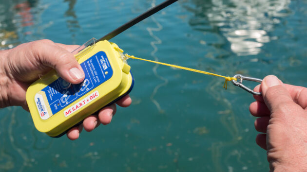
Modern automatic identification system (AIS) MOB and Search and Rescue Transmitter (SART) beacons are multi-constellation, multi-frequency receivers, and include many common and popular personal rescue devices owned and used by sailors.
Dr Ramsey Faragher told the RIN conference that examples of safety devices with GNSS capability include the Ocean Signal RescueMe MOB2 beacon, Jotron Tron 60GPS EPIRB, Weatherdock easyRescue AIS SART, and Iridium GMDSS.
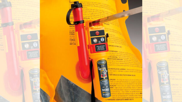
Dr Ramsey Faragher told the RIN biennial Small Craft Electronic Navigation conference that examples of devices with GNSS capability include the Ocean Signal RescueMe MOB2 beacon, Jotron Tron 60GPS EPIRB, Weatherdock easyRescue AIS SART, and Iridium GMDSS
What is spoofing and jamming?
Jamming – intentional blocking – occurs when powerful radio signals are broadcast on all of the GNSS signal frequencies.
Spoofing is the intentional transmission of deceptive signals, which could stealthily affect course or set the time on your chartplotter many years into the future so that software licences become invalid.
Rather than a complete loss of systems, Faragher said, “the real concern from your systems point of view, where the time gets passed around your vessel, is a spoofer can transmit time into the future or past and systems can then stop working properly.
“We have not designed and tested these systems to work in an electronic warfare environment.”
Hotspots can be found on www.gpswise.aero/map which shows more than 1,000 aircraft per day ‘jumping’ hundreds of miles from their true location due to spoofing.
While the level of GPS interference is “better than it looks” at sea level, the concern for SAR devices, Faragher said, is “there is no limit to the errors caused by spoofing. This can put you on the wrong continent, up in low-Earth orbit, or down at the centre of the Earth.”
While the Baltic Sea, Gulf of Bothnia, Gulf of Finland, and Black Sea may not be of key concern to UK recreational sailors, Faragher said GPS interference is a problem set to stay “wherever there’s geopolitical unrest, smuggling or other illegal activity.”
Two groundings and a collision last year caused by spoofing cost $100million in salvaging, repairs and delays to cargo.

We’ve added GNSS to things that shouldn’t need it to work”, warns RIN chief executive,
Dr Ramsey Faragher. Credit: Laura Hodgetts
‘Irrelevant’ to most
Felix Metzenthin, Weatherdock director of sales, said: “Long-range GNSS interference patterns over remote border regions, especially areas in the far east of Europe, are irrelevant to typical European cruising grounds, offshore sailing routes and near-coastal search operations.”
He said the “widely circulated GPS interference maps show precision degradation, not jamming and not spoofing” and were “usually reports that horizontal accuracy was temporarily worse – not that GNSS stopped working”.
Modern AIS-MOB and AIS SART beacons already incorporate multi-GNSS redundancy, multi-frequency resilience, AIS homing, and RF GNSS receivers designed for harsh environments.
Metzenthin added: “A rescue beacon with own GNSS capability and transmitting own position of the MOB in real time on the AIS and DSC system is by far the fastest and safest way of being rescued.
“To advise against the usage of these lifesaving devices is not leading to improved safety of sailors.”
However, Faragher warned that multi-constellation and multi-frequency receivers are not an adequate solution.
He said: “I agree that if you are not in interference regions, the equipment is expected to work fine.
“But these safety devices do not work as advertised when exposed to these known interference regions.
“People should be aware of that issue.”
What should sailors do?
Turning off the GNSS input into digital kit before entering spoofing hotspots, until back in safer waters, and learning traditional navigation methods, such as visual fixes, is vital.
Faragher added: “We need GNSS receiver manufacturers to make small changes which will have big impacts.
“These safety systems are incredibly powerful and useful in areas where there is no GNSS interference and I would trust my own life to them in certain parts of the world.
“But I know firsthand how easy it is to jam and trick the current generation of devices, even multi-frequency multiconstellation ones, and that needs to be taken into account if you operate near regions of known interference and your safety depends on them.”
PBO has contacted all the manufacturers mentioned in this article, and is still awaiting a response from all but Weatherdock.
Astro-section: the ‘most requested piece’ of e-nav guide
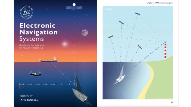
The RIN’s updated Electronic Navigation Systems – Guidance for safe use on leisure vessels includes an expanded section on GNSS which covers spoofing and jamming’; and a new focus on astronavigation as a vital backup to electronic methods
Since September 2025 the free Electronic Navigation Systems – Guidance for safe use on leisure vessels has been downloaded more than 1,206 times, with 16% (the most) users citing PBO as their source of information.
RIN Small Craft Group chairman Paul Bryans said both the original and updated booklets have been downloaded 7,452 times by users in 42 different countries: “It’s proved very popular worldwide.”
Version 2 includes an expanded section on crowd-sourced bathymetry; an expanded section on GNSS which covers spoofing and jamming’; and a new focus on astronavigation as a vital backup to electronic methods.
Bryans said: “The astro section was the most requested piece since the booklet was published.
“It includes the use of sextants at sea and tips on using apps for sight reduction.”
He added: “Practice with a sextant– you might need to use it if the GPS goes down.”
Find the free download at www.rin.org.uk/page/ENav
The guide is also available to buy in print via Imray and Bookharbour.

Embracing electronic navigation – one reluctant boater’s tale
Celestial navigation instructor Paul Jones reluctantly got to grips with electronic navigation and is now "out of the fog and…

When your electronic navigation autoroute settings go wrong
Gilbert Park helps a fellow motorboater achieve his first voyage to the Channel Islands and gets a lesson in the…
A beginner’s guide to the chartplotter
Whether you’re new to boating or looking to enhance your navigation with a phone, tablet or MFD, Ali Wood runs…
Want to read more articles like GNSS-enabled electronic devices have ‘cyber-security vulnerability’?

A subscription to Practical Boat Owner magazine costs around 40% less than the cover price.
Print and digital editions are available through Magazines Direct – where you can also find the latest deals.
PBO is packed with information to help you get the most from boat ownership – whether sail or power.
-
-
-
- Take your DIY skills to the next level with trusted advice on boat maintenance and repairs
- Impartial, in-depth gear reviews
- Practical cruising tips for making the most of your time afloat
-
-
Follow us on Facebook, Instagram, TikTok and Twitter