

After recent relatively quiet and dry conditions, much more unsettled weather is heading our way in the lead-up to Christmas with the second named storm of the season, Storm Barbara, expected tomorrow.
The UK Coastguard is among the emergency services and agencies to issue coastal safety warnings.
Coastal Operations Area Commander Ross Greenhill said: ‘There are a number of things we advise people about when bad weather is expected to hit the UK. We always advise people to check the weather and tidal conditions before the set out so that they can either prepare accordingly or consider whether they should even be going out at all.
‘At sea, changes in tidal streams can make conditions worse, particularly if the wind and tide are against each other and tidal heights may hide underwater hazards. You can check marine weather at this link: www.metoffice.gov.uk/weather/marine and tides at this link: http://easytide.ukho.gov.uk/EasyTide
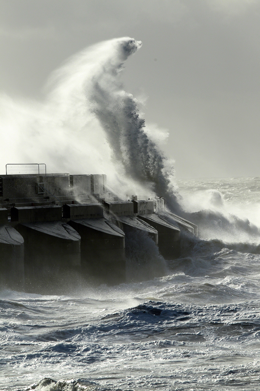
‘If you’re on the coastline, think twice about going out. And however dramatic it looks, don’t be tempted to take pictures by putting yourself at risk. A dramatic photograph or selfie is not worth risking your life for. If you are out and about, keep a careful watch on the incoming tide so that you don’t get cut off. Make sure you have a means to call for help like a fully charged phone.
‘We’re aware though that even the best laid plans and most carefully thought out voyage can go wrong. If you get into trouble call the Coastguard, by either dialling 999 or using one of the normal channels to call us.’
The windiest and wettest weather will be in the north and west of the UK with Met Office National Severe Weather Warnings in place.
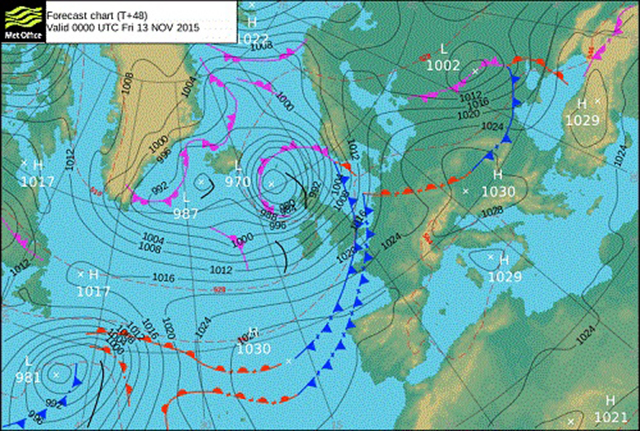
Deputy chief meteorologist, Chris Tubbs said: ‘Storm Barbara is now forming in the west Atlantic and will pass close to the northwest of the UK during Friday, bringing very strong winds and heavy rain, especially across the north and west of Scotland. This brings the potential for some structural damage, disruption to power supplies and travel, with restrictions on bridges and disruption to ferries likely.
‘The disturbed conditions look like continuing through the Christmas weekend with another vigorous low pressure system waiting in the wings. So, whatever your plans over the next few days it’s worthwhile staying up to date with the latest Met Office forecasts, which is easy to do on our app.’
The wet and windy weather, which is a result of a succession of deep Atlantic low pressure systems, is underway with the northwest expecting blustery showers accompanied by thunder and lightning today (21 December). A Yellow wind warning, meaning ‘be aware’, has been issued for today covering north and northwest Scotland. Showers in these areas will turn increasingly wintry even to low levels. Meanwhile a front will bring rain to parts of the south of England.
An Amber wind warning, meaning ‘be prepared’ has been issued for tomorrow, 23 December, covering northern and western parts of Scotland for the afternoon, evening and overnight into Christmas Eve (Saturday).
A separate Yellow wind warning covering northern parts of the UK is also in place. South or southwesterly winds will strengthen across the whole country, but gusts of 60 to 70 mph are likely quite widely in the warning areas, with westerly winds gusting 80 to 90 mph likely across parts of western and northern Scotland later on Friday and overnight into Saturday. Winds will then ease on Saturday morning.
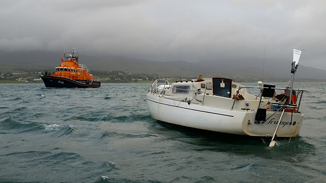
Storm-struck solo sailor thanks RNLI rescuers for saving his life
Castletownbere lifeboat volunteers spent 12 hours battling storm-force conditions to rescue a single-handed yachtsman 45 miles south of Mizen head…
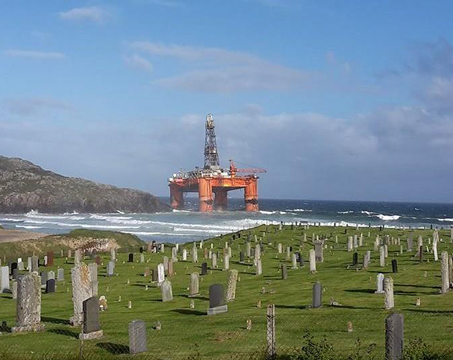
Drilling rig blown ashore during storm in Western Isles
A drilling rig has run aground on the Isle of Lewis in the Outer Hebrides of Scotland after being hit…

Clipper yacht retires after storm knockdown
Skipper Wendy Tuck and some crew sustained minor injuries when the Clipper Race yacht Da Nang Vietmam was damaged by…

Turn a storm jib into a trysail
A storm jib came with my second-hand 23ft (7m) Hunter Duette, but it couldn’t be run up the forestay because…
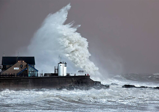
Storm Imogen batters parts of England and Wales
Violent storm force 11 is expected in areas off the south coast of the UK with wave heights reaching 16m.

7 Storm Jibs on test
We test 7 storm jibs, including wrap around and sleeved sails, to find out the best options for your boat
‘Storm Abigail’ to bring severe gales to Scotland
Across the far north and northwest of Scotland including the Western Isles and Northern Isles, severe southwesterly winds are forecast…
Name UK and Ireland’s wind storms this winter
The Met Office and Met Eireann have announced a pilot project to name wind storms that are expected to affect…

Storm-struck Dominica appeals for yachting community help
Dominica Marine Association is appealing to the international marine and yachting communities to bring supplies following storm devastation.

Storm surge breaches
One year on from the biggest UK storm surge for 60 years, new aerial photos have revealed details of breaches…
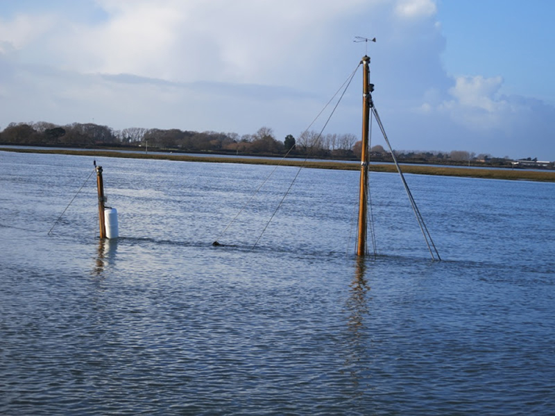
Yachtsmen warned of navigational hazards following storms
The latest in a string of violent storms has left a trail of navigational hazards around damaged coastal regions
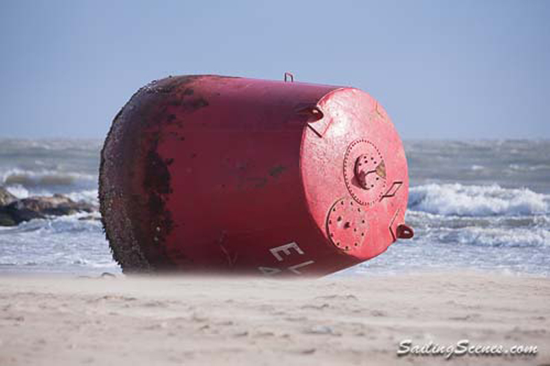
Large red buoy blown ashore by storms
Poole Harbour Commissioners are advising mariners to navigate with caution after two buoys are misplaced

Surge in boat insurance claims following storms
Batten down the hatches - there's more extreme weather on its way!