
Dick Everitt gives us a clear picture of the advantages to be gained from using radar to check our navigation
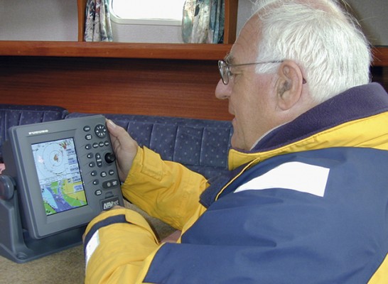
A combined radar display and chart plotter is great for showing how a radar picture relates to the chart, and it can quickly sort out unidentified targets, writes Dick Everitt.
Just put the cursor on the target, and if it doesn’t coincide with a charted object it might be another vessel.
Take care that the system is set up correctly, however: I’ve been on a radar demo boat where loads of experts got it wrong. We were running nearly due north and couldn’t get the radar image and
chart to align. We pushed many buttons, circled a few times to recalibrate the heading sensor and
then someone spotted that the chart was ‘north up’ and the radar was ‘head up’ – too many cooks!
Worse still is to ignore anomalies.

Radar overlaid on a chart plotter can help us interpret radar pictures
There was a tragic case of a ship running up a fjord at night with the chart plotter showing the ship symbol on land. The skipper ignored it because he knew the cartography and GPS offset didn’t agree in some places – but if he’d been checking the distance off with radar he would have seen he was too close in and heading towards some submerged rocks.
 Measuring range
Radar is very good at measuring distance off (or range), especially if the signal can bounce off a huge wall of rock. So if we wanted to stay a quarter of a mile off we’d set the variable range marker (VRM) to a quarter of a mile and keep it touching the edge as we sail in.
If we haven’t got a handy rock wall to follow but just a couple of headlands that show up well on radar, we can draw in our own line to run the VRM along. Some use a chinagraph pencil on the screen (or a plastic overlay), others stick on a piece of paper, but fancy modern sets with stabilised
systems can position electronic lines anywhere on the screen.
In certain situations we might need to use two or three different ranges marked on the radar screen
at night, or in reduced visibility, to help us keep a safe distance from different hazards as we approach them. As radar range is so accurate and quick to measure, we can also use it to check our position on the chart.
Simply put the VRM, or cursor, on three nearby easily identifiable targets and note their ranges.
On the chart, set a pair of compasses to each range in turn and draw in a short arc. Where they cross is our position, but remember ranges measured fore or aft are changing more rapidly than those abeam.

Rough and ready
Radar is not so good at measuring bearings, because the targets on the screen are elongated by the ‘beamwidth’ of the radar signal. For example, if we picked up a steel post we’d get an arc on the screen equal in length to the beamwidth of the radar signal. To take a bearing on it we would swing the electronic bearing line (EBL) to what we judge to be the centre of the arc.
And if we were taking the bearing of a headland we’d need to bring the EBL inland by an angle equal to half the beamwidth… which is all a bit rough and ready.
Getting a good picture and identifying targets can be hard, but many modern radar sets have
great factory reset defaults. If you enter port at night or in poor visibility, hit the ‘harbour setting’
and it should sort itself out while you concentrate on fi nding the moorings or berth. Even in
reasonable visibility, some channels can be confusing if you don’t have a chart plotter and may
show up better on the ‘bird’s eye view’ of a radar screen.

GPS and chart plotters are the main navigational tools, but radar gives a real-time picture of what’s around us
There’s an awkward dogleg channel favoured by Yachtmaster examiners who ask candidates that go aground: ‘Why didn’t you monitor the radar? The channel is marked with steel piles that show up well.’
GPS and chart plotters are the main navigation tools, but radar can help as it gives a real-time
picture of what’s around us, including things like wind farms that haven’t yet made it on to the chart and (if you’re lucky) broken water over reefs that have never been properly charted.
Search for more useful archive articles here via the PBO copy shop.
Nav in a Nutshell: Clearing bearings
In the first of his series on back-to-basics navigation Dick Everitt explains how to use a few simple lines to…

Nav in a Nutshell: What is a transit and how are they used in navigation
Lining up a pair of appropriate land features or navigation marks can help keep you safe, as Dick Everitt explains

Nav in a Nutshell: Navigate by ‘feel’ using an echo sounder
The ‘ping’ is king: You can navigate by ‘feel’ over the seabed in adverse conditions by using an echo sounder…

Nav in a Nutshell: Lighthouse characteristics on charts
Dick Everitt helps illuminate our understanding of lighthouse characteristics on charts, their dipping distances and loom...

Nav in a nutshell: Navigating at night
There’s no need to be in the dark if your preparation is thorough and easy to understand, says Dick Everitt…

Warning not to use LED bulbs in filament bulb navigation lights
Replacing filament bulbs with white LEDs in tricolour navigational lights could result in vessels not being insured, the Cruising Association…