Despite the accuracy offered by digital charting, updating electronic charts is a complicated process. Here's how to keep your electronic charts up to date

While we rely more and more upon our electronic charts, they are only as accurate as their source data.
Rocks might not move, but areas are resurveyed all the time – and sandbanks and mudbanks certainly do move, not to mention new buoyage and wrecks which appear all around our coasts – and we need to take advantage of any updates.
Updating paper charts is a simple matter of consulting the updates given in a relevant Notice to Mariners and transferring these via a trusty purple pen to the chart: David Rainsbury wrote about how to update your paper charts in PBO September 2014.
That’s all very well, but few people go to sea these days without electronic charts on board. There’s even more need to update electronic charts than paper charts, especially as chart plotters display your position to a few metres on the chart and people sneak ever closer to obstructions, believing their charts and position to be accurate to the nearest centimetre. But unlike paper charts, you can’t simply draw on the electronic versions. So how do you go about it?
Digital charts are available in a variety of formats and with hugely varying levels of complexity and price. Each company offers a range of update products. You can just buy a new chart each time, but this can work out to be extremely expensive, so it’s worth putting in some time to research the options which are open to you.
Chart plotters
There are three main providers of charts – Garmin (Garmin BlueChart) Jeppesen (C-Map) and Navionics. These companies offer their cartography on memory cards for plotters and each sell
their own iPad and Android tablet apps, which are much cheaper.
![]() Navionics
Navionics
Navionics are the only company to offer daily chart updates. First identify the type of Navionics charts and the type of memory card you are using: these are likely to be either SD cards, micro-SD cards or CompactFlash (CF) cards. You then order an update card online, which you plug into a card reader and onto which you can download an update from the Navionics server. Your existing card verifies that you are upgrading an older chart and can then be used as a backup.
The fee charged for the update also allows you to transfer your chart to a different area, or change media if required, eg for a new plotter.
Freshest Data
Navionics offer 12 months’ free updates with every Navionics+, Gold, or Platinum+ chart chip. This allows daily updates similar to those in the official Notices to Mariners, as well as Navionics’ SonarCharts (which use sonar logs from boats which submit their logs) and Community Edits (crowd-sourced data). After this 12 month period has passed, your update options are as follows:
- Navionics Silver – Silver charts, which are the most basic on offer, can be updated with an update card for £99.99 as long as they are on a chip and not embedded on the plotter. They are not available to buy separately.
- Navionics Gold – New chart £199. Gold charts can be updated by purchasing an update card for £99.99, exchanging the card, which also costs £99.99, or alternatively you can renew the Freshest Data subscription online for r120 (£95 at current rates).
- Navionics+ – New chart £199. Navionics+ gives you Gold charting plus SonarCharts and Community edits. Updating is as Gold charts.
- Navionics Platinum+ – Newchart £199.98 (XL Area) £299(XL3 area). These charts also feature 3D and satellite overlay, panoramic port pictures, dynamic tides and currents. Once the 12-month Freshest Data update period is over, you can exchange your chart for a new chart card for half price – this gives a further one year’s worth of updates after you have registered the card. Cost is £99.99 for XL areas, or £150 for XL3 areas.

Navionics’ daily updates include their crowd-sourced SonarCharts, based on data uploaded by users
Plotter Sync
Some new Raymarine plotters with Navionics charts can now be updated straight from a tablet computer via the plotter’s built-in WiFi. You’ll need Navionics+ or Platinum+ (see above) and a Navionics Boating app on your iPad or iPhone. You can then sync chart updates and upload any sonar logs to Navionics’ servers.
![]() Garmin BlueChart
Garmin BlueChart
Garmin have their own proprietary cartography for their range of plotters
and offer a range of options for their charts, which include the following.
BlueChart g2
The basic option. Small, from £99; regular, from £149; large, £199;
extra large, from £299.
BlueChart g2 Vision
Top-end charting, with 3D and satellite views. Small, from £149; regular, from £199; large, from £249.
It’s worth noting that on initial purchase you can update the SD card or preloaded charts
to their latest version for free – for the same (or equivalent) region as the original charts. You can do this yourself by downloading a web browser plug-in on your PC and either preparing a microSD/SD card by inserting it into your plotter (assuming it has charts loaded) and then inserting it into a card reader on your computer, or just plugging a preloaded chart card into your PC, whereupon the browser will show you your update options.
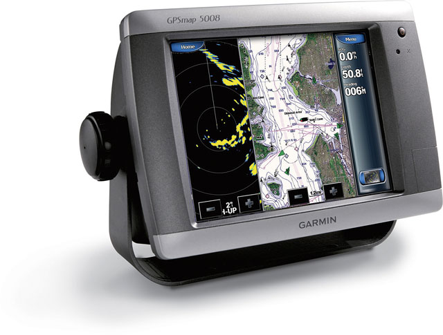
Garmin’s BlueCharts come with an initial option to update to the latest charts, and can later be updated for 50% off the price of a new chart
Updating preloaded maps
If your chart plotter came preloaded with BlueChart g2 charts, you can update them online or visit a Garmin dealer to buy the update on a card. Update cards are available for selected GPSMAP and echoMAP ranges, and these generally cost around 50% of the cost of the equivalent new charts.
Discounted updates
You can update your existing pre-programmed BlueChart g2 and BlueChart g2 Vision microSD/SD card for a discounted price. Updated charts are for the same (or equivalent) region as the original purchase. One discounted update is allowed, per card, per map version. A BlueChart g2 discounted update costs £49.99, while BlueChart g2 Vision discounted updates
cost £94.99 – regardless of size.
Older charts
Garmin say that their older charts on cartridge-type flash cards (called Traditional BlueChart) will be discontinued as of December 2014 (these stopped being supplied with new plotters in 2008). Watch this space for information on future support. Garmin’s website is www.garmin.com/mapupdates.
C MAP
![]() C-Map offer a range of update and upgrade options for their customers. Their charts are updated three times a year. Their charts fall into the following categories: NT+ (for older plotters) and MAX, MAX Pro and 4D.
C-Map offer a range of update and upgrade options for their customers. Their charts are updated three times a year. Their charts fall into the following categories: NT+ (for older plotters) and MAX, MAX Pro and 4D.
The coverage is in three categories:
Local Area – New chart £118
Wide Area – New Chart £195.99
Mega Wide Area – New Chart £269.99
First of all, identify your chart by the label on the cartridge and note the serial number, which shows the chart’s age. You can then enter it on Jeppesen’s website. With every update the chart’s version number increases by one. The official Jeppesen Marine position is that a chart is out of date when it is two versions old. If you wish to update your charts, you can either update or upgrade – there’s a difference!
- UPDATING allows you to bring one of their chart chips up to date within the same price class or technology. Updating costs roughly half the price of a new chart – in the case of the chip pictured right, that would be £98.80. You’ll need to visit your local dealer so that they can reprogram your card.
- UPGRADING means acquiring a higher price class or technology and is cheaper than purchasing a new chart outright, costing £148.80 for the Wide area chip below. As with updating a cartridge, you’ll need to visit a local dealer so that they can reprogram your card.
C-Map also offer a subscription ‘club’ service, Club Jeppesen. It offers one free update of a chart per year and reduced prices on additional card updates, discounts on other C-Map products and an extended warranty. Membership costs r94.80 (£77.65) per year, which works out much cheaper than a new chart – especially for Wide and Mega Wide areas.

As an example, this C-Map Wide area cartridge would cost £195.99 new, £98.40 to update or £148.80 to upgrade. Club Jeppesen membership would reduce the cost
iPad and Android apps
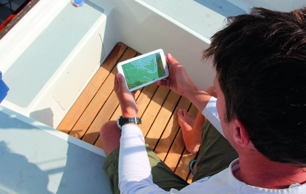
Updating the cartography in navigation apps varies between app developers
iPad and Android apps offer the same cartography as plotters but at a much lower price, but it can be very difficult to find out how often and how to update
the cartography for chart apps – often ‘updates’ only update the software and not the cartography.
Navionics currently offer a year’s subscription to Navionics+ as part of the app download, which gives you access to their daily ‘freshest data’ chart updates for 12 months. After this you’ll need to pay for a subscription, which costs £23.99 on iPhone and £39.99 on iPad. Other apps vary. Android app MX Mariner gives a year’s free updates with a purchase of its UKHO raster charts – but for the low purchase price of £4.24 for the UK South Coast, a yearly update won’t break the bank. Imray’s iPad chart app is updated once a year in the spring and these updates are available to owners of the app at ‘a reduced price’. Transas iSailor allows you to download updates to purchased charts for free, and as far as we could find out, that applies for the app’s lifetime. We tested 14 iPad and Android apps recently – you can read the test online here.
PC Navigation SoftwareGenerally, this is updated once a year – the UKHO, which licenses its data, has strict rules on what constitutes an update as opposed to a ‘new edition’. Visitmyharbour.com, which sells charts for the popular low-cost package SeaClear, offers its customers the chance to update for £6, or to upgrade to a new set of charts by sending back their old DVD of charts for it to be replaced for £20. Other software packages offer similar timescales – Maxsea, for instance, offers customers minor updates for free, but major yearly updates cost 50% off the full price. In practice this means you’ll be paying for updates annually and get other, smaller updates throughout the year.
Conclusion:
It’s a minefield out there: enough to make you pine for the days of a purple pen and Notices to Mariners! However, some companies do simplify the process significantly.
The easiest to update seem to be tablet nav apps which, with the tablet’s own data connection, make the process very simple. Otherwise, keeping your chart plotter’s digital charts up to date can be an expensive business, which goes some way to explaining the roaring trade in out-of-date chips on eBay.
Navionics’ Freshest Data solution, with 12 months’ free updates followed by a subscription, offers the most frequent updates, and their new Plotter Sync, which allows you to use your tablet to update certain Raymarine plotters, sounds very promising.
Similarly, C-Map’s Club Jeppesen offers savings if you have extensive chart coverage and want annual updates. Garmin offers updates for 30-50% off the cost a new card, with upgrades also available at 25% off.
The companies have to pay for their R&D and the cost of licensing the charts from various national authorities – but despite the accuracy offered by digital charting, the costs involved may mean that the boating public could be sailing around with charts more out of date than the paper charts we used to use!