
A new batch of chart plotters claim to offer features for sailing boats, including laylines and race starts. Ben Meakins puts them through their paces
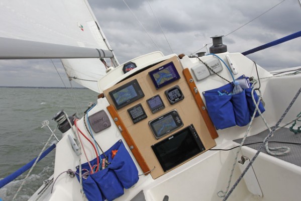
Chart plotters and instruments have been around long enough that they’re now considered standard equipment on most boats.
But sailors have had to take the functions offered with even the best chartplotters with a pinch of salt, especially when it come to sailing upwind. Until fairly recently they could only deal in straight lines – and there are few things more depressing than watching the ETA tick ever later on a long upwind leg.
B&G changed all that a few years ago with the introduction of their Zeus range of MFDs (multifunction displays). Here at last was a chart plotter designed for sailors. The data had long been available in their high-end Deckman racing software, but now it was available to cruising and club racers. They’ve been refining it ever since, helped by their racing expertise, and have recently launched the B&G Vulcan plotter, which is an entry-level touchscreen 7in MFD. This brings sailing features such as laylines within reach of many more sailors who might have been put off by the higher prices of the Zeus products.
Rivals Garmin acquired Nexus, a Swedish manufacturer of sailing instruments, in 2012, and late last year launched their own range of sailing instruments which incorporated some of the technology they had bought
with Nexus. Their new GPSMAP MFDs can make use of wind rose and layline overlays on the screen, as well as race start assistance. Their new range of gWind sensors are designed for use with this software.
We found that Raymarine had an imminent launch of sailing software, and managed to get hold of an exclusive pre-production copy to try out. It gives their MFDs the ability to display laylines and start lines and simplifies the process of inputting a racing route.
So, with the latest software from the three main manufacturers, we headed out to the Solent to put them through their paces.
How we tested them
We made up a temporary washboard to fit in the companionway of Polly, my Impala 28, and mounted our plotters and instruments into this.
One major advantage of NMEA 2000 is that it means all compatible instruments can talk to one another, regardless of manufacturer, so we connected our B&G, Raymarine and Garmin instruments to the same network. That meant they were getting the same wind, speed, depth and heading data and their functions and computations could therefore be easily compared.
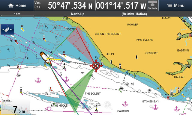
Starting from just off Cowes, we placed a waypoint on each plotter 4 miles upwind, at Pol Roger buoy just off Lee-on-Solent, hardened up and looked at each plotter’s presentation of laylines and upwind angles. We experimented with tidal offsets, true wind angles and real-time settings. As we approached the mark we could zoom in and compare each plotter’s predicted laylines.
Once round the mark, we looked at each plotter’s downwind settings, then set up a startline at Coronation buoy to try out each one’s start line features, if available.
Laylines
One of the major features of this new set of sailing software is the ability to understand that boats can’t sail into the wind. To do this, they use True Wind Angle (TWA), compass heading (HDG) and course over ground (COG) data to compute and display a parallelogram to show tacking angles and laylines for beating towards a waypoint. All the manufacturers use a similar system, which comprises red and green lines (representing port and starboard laylines) emanating from the waypoint. Some use arrows and vectors to display heading, COG, tide and wind, overlaid on the vessel’s icon.
B&G Vulcan 7

B&G’s laylines are clearly displayed. The dotted lines show historical layline and wind shifts, and, as here, can be set to take tide into account. Tacking time and distance can be viewed in the panel
B&G introduced the concept of laylines to plotters, and their clear and simple display has changed little since. A major advantage of the B&G kit is the ability to ‘damp’ the instrument data, which makes the laylines much easier to interpret as they aren’t swinging around as the boat goes over the waves.
Laylines are displayed as solid red and green lines, while an optional dotted line shows historical layline data to inform your decision about when to tack. They can be set to automatically take tide into account, and you can either use a manually-set target wind angle or the actual TWA. You can also upload a polar diagram if available, which will improve the accuracy of the system.

The SailSteer display can be overlaid on the chart.
You can add vector lines for heading and COG, or use the ‘SailSteer’ overlay which displays wind, tide, COG and a compass rose on your vessel. It’s a simplified version of the main SailSteer screen (see panel, p86).
Laylines are enabled via an easily-navigable ‘Layline settings’ menu.
A large amount of data can be displayed on a one- or two-column panel to the right of the screen, including ‘SailTime’, an ETA based on layline distance to sail, distance and time to each layline, which shows which tack is favoured and which will get you there faster.
As we approached the layline and considered tacking, the damped display showed clearly and equivocally when we should tack, with the historical wind overlay adding a useful safety margin in the shifty north-easterly breeze coming off the land.
Downwind, the laylines were equally easy to interpret, showing optimum angles to sail as well as laylines set to encourage you to gybe to bring us to the mark at optimum angle and speed – in our case a pre-set TWA of 145°, although a polar plot would give you a more accurate readout for your particular boat.
Note: We may earn a commission when you buy through links on our site, at no extra cost to you. This doesn’t affect our editorial independence.

Downwind, gybing angles are displayed, as are optimum laylines for best VMG (Velocity Made Good, dotted lines)
Raymarine e7
Raymarine’s laylines show historical windshift data (shaded areas) but little in the way of data. The laylines are showing as compensating for the strong west-going tidal flow on the day
Raymarine’s new Lighthouse II Release 14 software update will bring these layline features to a, c, e and g-series plotters, for free.
Laylines are displayed as long as you set the ‘boat type’ to either race sail, sail cruiser or catamaran, which will set the leeway calculations respectively, and as long as you are heading towards a waypoint that is less than 150NM away.
Laylines can be set to use Mirrored TWA, which uses the current TWA to show tacking angles and set the laylines accordingly. Alternatively, you can set them to a defined up- or downwind angle (45° upwind and
165° downwind as standard). You can also upload a polar diagram if available, which will give the best available results.
The laylines can also be set to take tidal flow into account, and can use a shaded area to show historical laylines – that is, to show a visual representation of where the laylines have been over a preset time period, which is useful as an at-a-glance guide to whether you’re about to tack on a close layline or a safe one.

Downwind, optimum gybing angles (dotted lines) are displayed and can be preset, or
a polar diagram can be uploaded
Damping the wind angle, boat speed and heading helps calm the laylines down and irons out any wild lurches, but we were unable to do this on the Raymarine plotter, although it could be done on the i70 instrument display.
There is also none of the data offered by the Garmin and B&G plotters – tacking time to waypoint, distance and time to Port and Starboard layline, etc. The vessel icon can have vector arrows for heading, COG, true wind and tide added.
Downwind, the laylines show gybing angles to the waypoint for optimum VMG. These differed from the other plotters as a set of dotted lines showing the optimum angles on each gybe, without any additional laylines shown, although these can be worked out by waiting until the angle bisects the waypoint.
Garmin GPSMAP 7407

Garmin’s laylines offer no historical wind data, but are shown here adjusted for tidal flow
Garmin have built on the know-how obtained from their purchase of Nexus to add a good set of sailing features to their MFDs.
First up is a useful set of layline features. These can be enabled via the ‘sailing’ smartmode page, and customised through a ‘sailing’ menu, where they can be adjusted for tide, and set to display fixed angles, both up- and down-wind, or related to actual TWA.
Where the Garmin pulls ahead of the Raymarine is in its display of data – time and distance to layline, sailing time to waypoint, etc, which is particularly useful when beating towards a waypoint.
Again, damping the data would offer much-improved response times and legibility, but there was no obvious way of doing this on the Garmin plotter. The Garmin system doesn’t offer any historical layline data, which would be a useful addition. In use, the laylines were effective and easy to understand. On the final approach they proved accurate, although they could have benefited from damping to steady them on our small boat.

Downwind: gybing angles and laylines
A wind rose, shown here, can be overlaid over the vessel, showing true and apparent wind angles or compass data. The screen can be customised with useful data in the two-column panel to the right of the screen. Menus are intuitive and vector lines can be added easily.
Downwind laylines are also available, which show gybing laylines for optimum speed to the leeward mark. These can be set at a fixed TWA or using actual wind, but would be more accurate if Garmin added the facility to upload a polar diagram for your boat.
Startlines
B&G
B&G have long led the market in this area, but startline data is currently only available on high-end systems connected to one of their standalone processor units. The Vulcan 7 can’t display startline information, even when connected to a processor: you’ll need to invest at least as far as one of their Zeus2 Touch MFDs to gain this facility. Processors are available in various guises, from the H5000 Hydra to H5000 Hercules and H5000 Performance, which have increasing levels of functionality. Starting from £1,799, they add significant levels of calculation and accuracy to the system. Startline assistance comes with all of these processors, together with a host of other performance functions beyond the scope of this test, but familiar to nearly every ocean racer of recent years.
We had a quick trial of this software at a press event in Miami earlier in the year, and the software displays line bias, distance to each end of the line and to the nearest point, time to burn and tidal data – a truly fully-featured system– but at a cost. Although we had a Zeus2 plotter on our network as well as the Vulcan, we didn’t have a processor, so were unable to try it out on this occasion. However, PBO understand from Navico that Vulcan will have the same start line functionality as Zeus2 after its latest software upgrade – along with other Zeus2 features.
Garmin

Garmin’s race start function comprises an overlay diagram with laylines for both ends and 1-minute lines (dotted lines), with a timer
Garmin’s startline software was impressive. You can place marks at both ends of the line, either by entering their lat/long or by ‘pinging’ each end – sailing to the mark and pressing a button as you arrive. The startline is then placed on the chart, but the really clever bit comes on the ‘sail racing’ combo screen. This shows a simplified diagram of the startline, with laylines for each end – particularly useful in the pre-start so that you can hit the layline for the committee boat easily without being above the layline and liable to be shut out by other boats. Also useful is a one-minute position line, based on a target speed which you can input. This dotted line shows where you should be with around 1 minute to go. There’s a ‘time to burn’ indicator to show how early or otherwise you are for the start too, and you can enter an offset for the distance from bow to GPS antenna. All in all, this is a useful function that, if visible from the helm, would be an invaluable aid to getting good starts.
There is no line bias information, which is a shame, as the necessary data is all there and available. The race timer, also available on this screen, can be synchronised to the nearest minute, up or down. It links with the software to tell you how early or late you are for the start.
Raymarine

Raymarine’s race start functionality lets you ‘ping’ both ends of the line to create a simple line displayed on the chart, as well as a race timer
Raymarine’s latest update enables some startline features in compatible products. These features aren’t as comprehensive as Garmin and B&G’s offerings, but could nonetheless be useful as a reference. You can ‘ping’ both ends of the line, input the waypoints manually, or select them from a list of pre-entered waypoints, and the start line will appear as an overlay on the chart.
There aren’t any simplified graphical diagrams, but it does give you an indication of where the startline is, which, combined with wind and tide vectors on the vessel icon, gives a useful indication of line bias and would help to show where it is and how close you are.
Below, the screen shows the boat crossing the line at the starboard end and on starboard tack, with the yellow wind angle giving an indication of line bias. It’s not spelled out for you as it is on the other systems, but, interpreted correctly could be of some use to a navigator.
A race timer can be accessed via its own menu, listed under ‘Navigate’ and ‘Race Timer’, and can be set to countdown from any value, and also overlaid on the chart screen. It can be synchronised at a gun and made to skip to the next minute if required.
Inputting routes via shortcodes
 One other feature that Raymarine have introduced is the ability to quickly input routes via their shortcodes, by entering the ‘routes’ menu and selecting ‘build using racemark IDs’. For instance, Solent racers will be familiar with the shortcodes (4J, 3A, etc) given by the SCRA to racing marks, and these can now be combined into a route by typing in the shortcodes, separated by commas to create a quick route. You can then go through the route plan and mark each waypoint with its rounding direction, which will then show on the chart with an arrow indicating which way to round it.
Instrument pages

Garmin
Garmin’s instrument screen can be customised as required, but is useful ‘out of the box’, as seen here. As such, it displays graphs for average wind angle and true wind direction, so they can be monitored for a customisable period of time. Displays show apparent and true wind angle, as well as tidal rate and flow, overlaid on a compass-rose-style overhead view of the boat. Other useful information such as boat speed, depth and VMG can also be displayed, but not laylines. A larger screen would make this data easier to see and understand from the helm.

B&G’s SailSteer screen can be overlaid on the chart, but is also visible separately. This is a compass rose overlaid on the vessel which displays COG, heading, wind data, laylines (both real-time and historical, which appear as the shaded colours), speed, tide and as much data as you want. It takes a little time to get to grips with the screen, but once you’ve familiarised yourself with what each icon means, it provides a useful graphical representation of what’s going on. The central rose is big enough to see from the other end of the cockpit when under way.

Raymarine
Raymarine’s sailing instrument page can be customised to display anything that is available on the SeaTalkng network. We selected tide, apparent and true wind, COG and heading, with waypoint information (displayed as the waypoint’s symbol on the compass) also overlaid on the useful ‘dial’ type screen. Laylines are not displayed. The ‘dial’ displays offer a useful interpretation of the data available but, on the 7in screen, we found them too small to steer by and stuck to the digital readouts when viewing from afar. A bigger screen would resolve this issue.
PBO Verdict
It’s great news that manufacturers are finally giving sailors some functionality to play with.
First of all, they look nice and make interesting shapes on the screen, but is it actually useful to have laylines overlaid on a chart? Are they of real use, or are they just a gimmick?
In my opinion, they are useful – as long as the instruments are all well calibrated so that wind and tide calculations are accurate and everything is suitably damped. Yes, you can make these calculations in your head or on a chart, but it’s nice to have
them easily to hand, particularly when beating towards a headland or buoy in strong tide.
Particularly useful is the ability to see historical wind data overlaid on the laylines, allowing you to make a call on how early to tack. The tidal adjustments on the laylines were also useful and got us to tack in the right place despite a strong west-going tide on our test day.
In terms of comparisons, top of the tree is B&G’s system, which is not only well presented but highly customisable and expandable. Garmin’s offering was also impressive, with some well-thought- out functions. Raymarine’s new update is available to most of their existing MFDs for free, which is a plus for existing owners. It lacks some features when compared to Garmin and B&G, but their laylines offer a useful graphical representation, with the historical wind data being particularly useful.
To use these features with any level of accuracy, you’ll need to make sure that:
- You have wind, COG, boat speed and heading data fed to the NMEA 2000 network.
- Instruments must be well calibrated – even a small error in heading, speed and wind readings can combine when processed into a large error that will make the readouts erroneous.
- Data is damped, if necessary. On a small boat, we found that the wind angle data jumped around a lot unless damped: when thus steadied, the laylines stopped jumping around and became much more legible and easy to understand.

The SailTime data available on B&G – which gives time and distance to sail upwind, taking laylines into account – is also useful, especially when planning for headlands and tidal gates, as well as racing.
This data is also available on the Garmin system, but not on Raymarine’s. Race start features are not likely to be any use to you unless you’re a regular racer, and there is no substitute for starting practice – but Garmin’s race start features really stand out as being simple to use and provide a very useful overview of the startline and timing, although it’s a shame that line bias is not included.
B&G’s is fully featured, but only available on their higher-end plotters. Raymarine’s is a step in the right direction, but of limited use when compared to the large amount of data available on Garmin’s system.