
We delve into a plethora of sailing weather apps and websites in an attempt to discover which ones offer the most comprehensive detail and the best value

The transformation in the availability, frequency and accuracy of weather forecasts available to the cruising sailor in the past decade has been truly amazing. Awaking, bleary-eyed, for the 0540 Shipping Forecast is but a distant memory for most sailors these days.
Internet weather gives us instant, six-hourly updates with wind and gust speeds, precipitation, temperatures, pressure and wave forecasts, all available at the touch of a button or the tap of a touch-screen. All you need is a mobile data signal or WiFi and you have the kind of weather data for which our forebears would have given their back teeth.
However, with choice comes complexity. With so many boating apps available, which should you choose? Which computer models are they based upon, and are any more accurate than others?
Using online weather forecasts
Forecasts are so detailed now that it can be easy to be seduced by them – but don’t despair if the forecast looks awful a week away. A forecast for more than seven days ahead is likely to be little more than highly-educated guesswork. Closer in, the accuracy improves – and for a day or so ahead, modern forecasts are invariably correct.
Modern forecasts are based on numerical weather prediction (NWP). The two main centres are the UK Met Office and the US National Weather Service, which together provide the worldwide service to aviation, and it is from here that most forecasts originate. Numerical weather prediction takes into account all the physical factors driving the atmospheric conditions – the spin of the earth, heating by the sun, topography and the effects of water – and this raw data is fed into enormous supercomputers along with observations from the relevant area. These huge volumes of data are crunched by the machines to produce a forecast.
In all forecasts, there is much approximation and estimation of the physics. How the raw data is dealt with differs slightly as it is run through the different computer models. It’s useful to know which model each forecast uses: most, including nearly all GRIB files, use the American GFS model; others include NWW3, WRF, COAMPS, NAVGEM and ECMWF, as well as proprietary models. Most weather charts will have their origins printed somewhere in a margin, so it’s worth checking to see which of your forecasts can agree.
A consensus
Where all the available forecasts agree, you can be fairly sure that the weather will do what they say and you can use them to plan a cruise with a fair degree of confidence. If they’re inconsistent, you should be more wary, as the outcome is more difficult to predict and will be subject to change. You should never rely upon one source only. Weather guru Frank Singleton told PBO: ‘The value of using several forecasts cannot be over-stressed. There is considerable benefit in having input from a human forecaster who can use intelligence and experience to interpret the computer output.’ So, look at as many online forecasts as you like – but don’t forget to check the synoptic chart as well, just in case.
Here are some of the most popular sites and sailing apps.
Windguru

Website, iOS and Android apps
Windguru offers six-hourly updates based on the GFS and WRF models. GFS is available free to view, but the WRF model is delayed by six hours unless you subscribe (€19.90 a year). Resolution is 27km for GFS, which gives three-hourly forecasts, and 9km for WRF, which gives hourly forecasts. Forecast maps are also available.
Windyty

Model used: GFS and NEMS
A recent find, this site has interactive, animated weather charts for the whole globe. You can zoom out to see global weather patterns, or zoom into a local area to see wind, rain, pressure, waves and other data. It’s a really useful and easy-to-read visualisation of weather patterns, and a great way to identify and track incoming frontal systems – or to pass
the time watching the mesmeric patterns!
BBC Weather
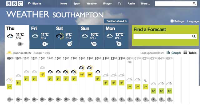
Website, iOS and Android apps
Unfortunately, the BBC’s weather offering for sailors lags way behind the competition. Wind data is mainly presented as gusts, and while there is an hourly forecast, it’s much more useful for finding out whether it will rain than for looking at the wind. Marine forecasts are available under the ‘coast and sea’ tab, in the usual Shipping Forecast and Inshore Waters Forecast formats – but this is clumsy, dated and not as detailed as other available forecast sources.
Passage Weather

Passageweather, designed for sailors, uses forecasts based on the GFS, COAMPS and WRF models. It overlays wind barbs on forecast maps at three-hour intervals,
and there are also charts for surface pressure, wave height and direction, visibility and precipitation and sea temperature.
PredictWind

Website, iOS and Android apps
An expensive option, this – but PredictWind offers high levels of detail and, it claims, the highest resolution and most accurate forecasts on the internet. Indeed, it’s impressive. The resolution is 1km at its best, and the site uses its own PWG and PWC models. Prices range from £9 to £399 a year, depending on the level of access required – if you want 1km resolution, then you’ll need to pay the money! At the highest end, it also includes weather routeing.
Met Office

Website, iOS and Android apps
The Met Office publishes its Shipping Forecasts, Inshore Waters Forecasts and gale warnings for mariners on its website. These follow the same pattern as those broadcast by the coastguard. Surface pressure charts are also available. Greater wind data is available on an hourly forecast under their standard forecast tab, with direction, base and gust strength displayed. Of more use is their interactive UK wind map, which shows wind strength on a grid overlaid on a map. This can be set to show base wind and gust strength and direction. It can be tricky to navigate the Met Office site, but the information is available – albeit in a less easily decipherable display than some others.
Weatherweb

Dr Simon Keeling’s site offers a subscription service: for £65 every six months you get access to all of his unique ‘musings’ videos, which discuss the developing weather, as well as looking at the month ahead, and the long-term trends which will affect the upcoming weather. It’s a great site, which will educate you as well as giving you the forecasts you need. Weather maps are available which use not only the usual suspects – GFS, etc – but also ‘pro models’ developed by Dr Keeling and his associates. A free three-day trial is available.
Windfinder

Website, iOS and Android apps
Windfinder is based on the GFS model on a 13km resolution, and offers wind and wave data as well as weather reports. You can upgrade to a ‘Pro’ version of the apps, which give you high-resolution wind predictions on an hourly basis and wind forecast maps.
Metcheck

Under the ‘Sailing Forecasts’ tab, Metcheck provides a useful forecast for inshore waters areas as well as selected sailing clubs. It uses NWW3 and GFS models. It’s a little simplified – no gust data can be obtained – but the available data is well presented and easy to read.
Yr.no

This Norwegian site displays wind speed in m/s, but is a useful reference: and to get to knots, just double the m/s speed. Wind and weather forecasts are available on an hourly basis, with wind
barbs showing the speed and direction. Long-range forecasts are available up to 10 days ahead. Sadly, wind maps – which are presented in a useful fashion – are only available for Scandinavia and the eastern North Sea. Nonetheless, the remainder of the site still makes it a really useful planning tool.
WetterZentrale

This website might be written in German, but this site is perhaps the biggest one-stop resource out there. All free, it collates forecasts from all the major forecast centres in one place. It can display forecasts up to 384 hours in advance (that’s 16 days) – useful to watch, but not as accurate as you might wish. Nonetheless, it can display GFS, GEM, JMA, NAVGEM, UK Met Office, ECMWF, ENS and WRF, as well as many other forecast models. Click on ‘Weitere GFS Karten’ and
‘10m Wind’ (Mitteleur) for the GFS wind forecasts. NAVGEM forecasts also cover the UK and offer a useful comparison, and Met Office synoptic charts are available. Wetterzentrale can be tricky to get the hang of, but the data is there and is really useful.
Yachting Weather app

iOS and Android apps
Free, with in-app purchases
This app uses GFS data from weather365.com, and gives three-hourly forecasts. It’s
well presented, and gives simple wind, pressure, swell and cloud/rain data in a tabular format for anywhere in the world. It’s simple but clear, and easy to use.
XC weather

XC Weather, originally developed for gliders, combines forecasts based on the GFS model with a network of weather stations for real-time wind data across the country. It displays wind history at these sites, and forecasts with wind gust speed on a three-hourly basis. It works really well on a computer screen, but is a little fiddly to use on a touch-screen.
Rain Radar UK Free

iOS and Android app
This app shows real-time data from rain radars. It allows you to track the progress of rain showers – particularly useful if you’re looking to put on some paint, or wondering when the rain will stop. Similar data is available online on the Met Office website.
Theyr

Website and iOS app
Theyr offer various subscription-based services, mostly based on WRF models. Standard registration is £99.99 per year, and premium (with higher resolutions and other models) is £199 a year. Nevertheless, you can view their latest ‘low precision’ forecast for the next 144 hours on their website for free, which shows wind, wave, pressure and temperature. The animations are clear and easy to view, and well visualised. You’ll need to subscribe to view their standard (12km resolution) and high precision (2km resolution) forecasts.
Meteociel.fr
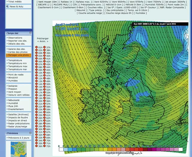
Website, iOS and Android apps
This French website, also available as an iOS and Android app, gives a real-time wind map, as well as useful WRF-based wind maps (click on ‘Valeurs vent rafales’). It combines the wind arrows with isobars to give you a very handy overview not only of forecast wind, but also approaching weather fronts. It’s worth dealing with the language barrier to get into!
PBO Verdict
All these sites and apps will give you a weather forecast, but they vary in the quality and quantity of data available. We found PredictWind to offer excellent clarity, resolution and accuracy, but at a substantial cost for the pro features. Its basic level, at £9 a month, gives a good enough level of data for cruisers. Windyty is a great, free way to see what’s going on in a well-presented format, while Windguru is a PBO favourite that works well. For longer-range forecasts, WetterZentrale and yr.no are both useful. All of these show how far we’ve come since the shipping forecast was the only available forecast – it’s just a shame the BBC’s website has yet to catch up!