
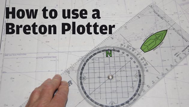
Breton Plotters are simple to use in practice, but tricky to explain on paper – it’s much easier if you have one in front of you as you follow the explanation. But here goes…
If we want to draw a line at 115°M, set the compass rose to that position allowing for variation (see photo below).
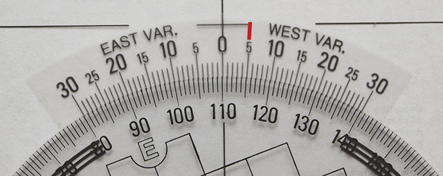
Set the compass rose to 115°– we’re lining it up with the 5° west variation
Then move the whole plotter around until north on the compass rose points to the top of the chart and align the grid with any handy perpendicular chart lines (see photo below), then draw your line.

Line up the ‘north’ grid with any perpendicular chart lines
To read off a bearing between two points is the reverse procedure: line up the edge of the plotter with the two points, align the grid to north and read off the bearing – simple.
To shape a course use the graduations on the plotter edges. On some models these equate to miles at different chart scales, but I find they can be confusing so just use them as ‘units’.
We can then draw a small scale-drawing of the vector triangle on the chart using ‘units’ and not great big sea miles off the latitude scale. The angles will still be the same.
- Draw a line where we want to go
- Measure the angle of the relevant tidal arrow in the tidal atlas with the Breton Plotter
- Mark off an hour’s worth of tidal ‘units’ on the chart, at that angle
- Instead of swinging off an arc of boat speed ‘units’ with a compass use the edge of the plotter. Pivot it against a pencil point if that helps
- Align the grid and read the course in magnetic from the variation scale on the plotter
- Adjust for leeway
Hopefully the ship’s compass is free from deviation, caused by metal or electronics on board: most are, but it pays to check occasionally. If it can’t be corrected out, create a ‘deviation curve’ as explained in any nav textbook.
Then the corrected course will be in °C (degrees compass).
Later in the series we’ll see that doing some chart work helps to deal with changing tidal streams, tacking to clear headlands and checking waypoint positions. GPS is great, but it still pays to know the basics.
This Nav in a Nutshell article by Dick Everitt was published in the February 2012 issue of PBO. For more useful archive articles explore the PBO copy shop.
Nav in a Nutshell: Clearing bearings
In the first of his series on back-to-basics navigation Dick Everitt explains how to use a few simple lines to…

Nav in a Nutshell: What is a transit and how are they used in navigation
Lining up a pair of appropriate land features or navigation marks can help keep you safe, as Dick Everitt explains

Nav in a Nutshell: Navigate by ‘feel’ using an echo sounder
The ‘ping’ is king: You can navigate by ‘feel’ over the seabed in adverse conditions by using an echo sounder…

Nav in a Nutshell: Lighthouse characteristics on charts
Dick Everitt helps illuminate our understanding of lighthouse characteristics on charts, their dipping distances and loom...

Nav in a nutshell: Navigating at night
There’s no need to be in the dark if your preparation is thorough and easy to understand, says Dick Everitt…

Nav in a nutshell: Navigate with radar
Dick Everitt gives us a clear picture of the advantages to be gained from using radar to check our navigation

Nav in a nutshell: Looks good on paper
Up-to-date printed paper charts are a good bet for identifying your position – but they do have their limits, says…

Nav in a nutshell: Electronic charts
Dick Everitt assesses the differences between raster and vector charts when deciding on which chart plotter to buy

Nav in a nutshell: Coping with currents
Dick Everitt explains how sailors can apply knowledge of tidal streams to ensure that water flow is a help, not…

Nav in a nutshell: Know tidal vectors
'It’s easy for any sailor to remember how to draw tidal vectors with a handy little aide-mémoire!' Says Dick Everitt.…

Nav in a nutshell: Shaping a course
GPS is not infallible, so it makes sense to know the basics of shaping a rough ‘course to steer’ on…